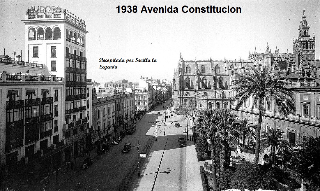
Avenida de la Constitución de Sevilla es la vía
pública más importante que comunica con el centro histórico de la ciudad
partiendo de la plaza conocida como Puerta
de Jerez hasta la Plaza Nueva considerado el centro de la
ciudad, donde se ubica el edificio histórico del Ayuntamiento de Sevilla. Tiene
una longitud de 600 m.
La actual avenida quedaba fuera de la muralla que
marcaba el límite urbano en la época romana. Alguno de sus tramos llegó a
estar ocupado por un desaparecido brazo del río Guadalquivir, que procedente de
la Alameda
de Hércules atravesaba
la Campana, la Plaza
Nueva y
desembocaba en la zona del Arenal.
La zona
adquirió importancia económica a partir de la Baja Edad Media, principalmente a raíz de la
construcción de la nueva mezquita mayor (inaugurada en 1176) y de la
posterior conquista castellana en 1248. Allí se fueron instalando comerciantes genoveses, cambistas y artesanos como
plateros (siglo XIV), impresores de libros (finales del siglo XV) y sastres (siglo XVI).
Tras el
descubrimiento de América, y la elección de Sevilla, como puerto exclusivo del
comercio indiano, se incrementó la actividad comercial de la ciudad, las gradas
de la Catedral servían de lugar de reunión de los comerciantes para sus
negociaciones, allí se publicitaban los viajes proyectados y los productos
llegados desde ultramar. Su punto central era la denominada fuente del Hierro,
enclavada en el lugar que actualmente ocupa la Iglesia del Sagrario. Durante la segunda mitad del siglo
XVI, el Cabildo de la Catedral, para evitar los excesos cometidos en la zona
por lo comerciantes, instaló columnas con cadenas en los alrededores del templo
y contrató alguaciles que evitaran el paso por la calle, de animales de carga.
Antes las quejas del Cabildo Metropolitano, el rey Felipe II decidió la
construcción de un edificio para sede de la Lonja, que se llevaría a cabo en la
misma Avenida, junto a la Catedral, y que es actualmente sede del Archivo de
Indias.
La actual
avenida de la Constitución reúne en una sola vía, el resultado final de varias
transformaciones planteadas desde el año 1863 y puestas en ejecución a partir
de 1911 por el entonces alcalde, Antonio Halcón y Vinent, en el marco de las
reformas unidas a la proyectada Exposición Iberoamericana de 1929. Con anterioridad existían la calle
Génova, que comenzaba en el edificio del Ayuntamiento, la de Gradas, delante de
la Catedral, la de la Lonja, delante del actual
Archivo
de Indias. Desde este
punto no existía una avenida y si una serie de edificaciones que hacían
imposible el acceso directo hasta la actual puerta de Jerez, continuando se
encontraba en primer lugar, el edificio del antiguo seminario de Santa María de
Jesús hasta llegar a la Casa de la Moneda y finalmente hasta la Puerta de Jerez
The Avenue of the
Constitution of Seville is the most important public road that connects with
the historic center of the city starting from the square known as Puerta de
Jerez until Plaza Nueva considered the center of the city, where the historic
building of the City Hall is located of Sevilla. It has a length of 600 m. The
current avenue was outside the wall that marked the urban limit in Roman times.
Some of its sections became occupied by a missing arm of the Guadalquivir
River, which from the Alameda de Hércules crossed the Campana, Plaza Nueva and
ended at the Arenal area. The zone acquired economic importance from the Low
Middle Age, mainly as a result of the construction of the new greater mosque
(inaugurated in 1176) and of the later Castilian conquest in 1248. There they
were installed Genoese merchants, moneychangers and artisans like silversmiths
(fourteenth century), printers of books (late fifteenth century) and tailors
(sixteenth century). After the discovery of America, and the election of Seville,
as the exclusive port of Indian commerce, the commercial activity of the city
increased, the steps of the Cathedral served as meeting place for the merchants
for their negotiations, trips were advertised there projected and products
arrived from overseas. Its central point was the so-called Fuente del Hierro,
located in the place currently occupied by the Church of the Tabernacle. During
the second half of the sixteenth century, the Cabildo de la Catedral, to avoid
the excesses committed in the area by merchants, installed columns with chains
in the vicinity of the temple and hired sheriffs to avoid the passage through
the street of pack animals . Before the complaints of the Metropolitan Council,
King Felipe II decided the construction of a building for the headquarters of
the Lonja, which would take place on the same Avenue, next to the Cathedral,
and which is currently the seat of the Archivo de Indias.
The current avenue
of the Constitution brings together in a single way, the final result of several
transformations proposed since 1863 and implemented from 1911 by the then
mayor, Antonio Halcón and Vinent, within the framework of the reforms linked to
the projected Ibero-American Exposition of 1929. Previously there was Genoa
Street, which began in the City Hall building, that of Gradas, in front of the
Cathedral, that of La Lonja, in front of the current Archivo de Indias. From
this point there was no avenue and if a series of buildings that made direct
access impossible to the current door of Jerez, continuing was in the first
place, the building of the old seminary of Santa Maria de Jesus to reach the
House of the Currency and finally to the Puerta de Jerez.
Primer tramo (cruce c/ Alemanes y García de Vinuesa)
El nombre
original de este tramo desde el siglo XIII era calle de Génova. Entre 1897-1931
recibió el nombre de Cánovas del Castillo. Entre 1931 y 1936, durante la
Segunda República Española, se llamó Libertad y desde 1936 hasta 1980 José
Antonio Primo de Rivera.
Se inicia
este tramo desde el Ayuntamiento en dirección a la Puerta de Jerez. Los edificios de arquitectura
regionalista de esta primera parte de la Avenida, están vinculados con el
ensanche acometido durante los años veinte del pasado siglo. El primer inmueble
que se encuentra, en el número 2, denominado edificio de "La Adriática", de estilo neomudéjar y que
albergaba la confitería de Filella, es obra de José
Espiau y Muñoz, fue
construido entre 1914 y 1922. En la misma acera se encuentran cuatro edificios
de Aníbal
González casi
consecutivos, el número 6 (año 1921), el número 10 (1913-1914) y los números 12
(1912-1914) y 14 (1915-1917) que hace esquina con la calle García de Vinuesa,
éstos dos últimos componen la actual sede del Banco Popular.
En la acera
opuesta, de los impares, destaca en su tramo inicial, la construcción del Banco
de España, obra del arquitecto Antonio Illanes, que es un ejemplo de
monumentalismo clasicista, realizado entre 1925 y 1928. A continuación se
encuentra el edificio del antiguo Banco Central, hoy Banco
de Santander, construido
en 1952, proyecto de Vicente Traver. Por último antes de llegar a la
catedral se puede contemplar la esquina formada por el edificio denominado de
la Punta del diamante.
First section
(junction with Alemanes and García de Vinuesa)
The original name
of this section since the 13th century was Genoa street. Between 1897-1931 it
received the name of Cánovas del Castillo. Between 1931 and 1936, during the
Second Spanish Republic, it was called Libertad and from 1936 to 1980 José
Antonio Primo de Rivera.
This section starts
from the Town Hall in the direction of Puerta de Jerez. The buildings of
regionalist architecture of this first part of the Avenue, are linked to the
widening undertaken during the twenties of the last century. The first building
that is located in number 2, called "Adriatic" building, of
Neomudéjar style and that housed the confectionery of Filella, is the work of
José Espiau y Muñoz, was built between 1914 and 1922. On the same sidewalk
there are four buildings of Aníbal González almost consecutive, number 6 (year
1921), number 10 (1913-1914) and numbers 12 (1912-1914) and 14 (1915-1917) that
is on the corner with García street Vinuesa, these last two make up the current
headquarters of Banco Popular.
On the opposite
side of the odd, highlights in its initial section, the construction of the
Bank of Spain, the work of the architect Antonio Illanes, which is an example
of classic monumentalism, made between 1925 and 1928. Next is the building of
the old Central Bank, today Banco de Santander, built in 1952, Vicente Traver's
project. Finally before arriving at the cathedral you can see the corner formed
by the building called Punta del diamante.
Segundo tramo (hasta Casa de Contratación)
Este tramo
de la avenida, recibía desde el Siglo XIII, el nombre de calle Gradas, en el
tramo existente frente a la catedral; y calle de la Lonja al correspondiente al
frente de la Casa Lonja, actual Archivo de Indias. En la primera mitad del
siglo XIX se conoció tal sector como Punta del Diamante, y desde 1868 hasta
1877 como Catedral, Gran Capitán desde 1877 hasta 1917, Reina Mercedes desde
1917 hasta 1931, Libertad desde 1931 hasta 1936 y Queipo de Llano entre los
años 1936 y 1980.
Este tramo
se inicia en el cruce de la Avenida con las calles Alemanes y García de Vinuesa
y en su lado izquierdo se localizan los inmuebles de mayor monumentalidad
histórica y artística de toda la Avenida. En primer lugar se sitúa la Iglesia del Sagrario (Sevilla), el templo, cuya construcción se
inició en 1618, se encuentra integrado en la gran manzana formada por la
Catedral y el Patio de los Naranjos. En su interior destaca el magnífico
retablo mayor que representa el descendimiento de Cristo, elaborado por Francisco Dionisio de Ribas, la estructura y por Pedro Roldán las tallas. A continuación y sin
separación en sus fachadas se encuentra la Catedral. Por último el Archivo de Indias.
En el acera
contraria destacan el edificio de José Espiau, levantado entre 1927 y 1929,
como fachada del viejo colegio de San Miguel, frente a la catedral, también
sobresale el edificio de Correos y Telégrafos, levantado entre 1927 y 1930 obra
de los arquitectos Joaquín Otamendi y Luis Lozano y en la continuación, el
edificio de la Aurora, realizado entre 1933 y 1936 por Antonio Illanes.
Edificio de
la Compañía de seguros la Aurora, construido entre 1933 y 1936, siendo el
arquitecto Antonio Illanes del Río.
Second section (up to the Contracting House)
This stretch of the avenue, received from the thirteenth century, the name of
street Gradas, in the existing section in front of the cathedral; and Calle de
la Lonja to the one in front of Casa Lonja, current Archivo de Indias. In the
first half of the 19th century, this sector was known as Punta del Diamante,
and from 1868 to 1877 as a Cathedral, Great Captain from 1877 to 1917, Queen
Mercedes from 1917 to 1931, Liberty from 1931 to 1936 and Queipo de Llano between
the years. 1936 and 1980. This stretch begins at the junction of the Avenue
with Alemanes and Garcia de Vinuesa streets and on its left side are the most
monumental and artistic monuments of the entire Avenue. In the first place is
the Church of the Sagrario (Seville), the temple, whose construction began in
1618, is integrated into the large block formed by the Cathedral and the Patio
de los Naranjos. In its interior it highlights the magnificent main altarpiece
that represents the descent of Christ, elaborated by Francisco Dionisio de
Ribas, the structure and by Pedro Roldán the carvings. Next and without
separation in its facades is the Cathedral. Finally, the Archivo de Indias. On
the opposite side stand the building of José Espiau, built between 1927 and
1929, as a facade of the old school of San Miguel, in front of the cathedral,
also stands the building of Post and Telegraph, built between 1927 and 1930
work of the architects Joaquín Otamendi and Luis Lozano and in the
continuation, the building of the Aurora, made between 1933 and 1936 by Antonio
Illanes. Building of the Aurora Insurance Company, built between 1933 and 1936,
with the architect Antonio Illanes del Río.


Tercer tramo
Comienza en
el cruce con la calle Santo Tomás. A la izquierda en la misma esquina con la
calle mencionada se localiza la Torre Abd el Aziz, que formaba parte de una de las
murallas de la ciudad, avanzando por el lado izquierdo se encuentra la actual
oficina de turismo, construcción de Aníbal González del año 1926 y a
continuación el edificio de Seguros Santa Lucía, obra de José Espiau del año
1910, de estilo predominantemente modernista, con salida también a la calle San
Gregorio, este inmueble presenta una larga fachada, dividida en secciones
verticales, donde destaca el uso de la cerámica en su decoración. El proyecto
inicial de construcción, para Juan Bautista Calvi, contemplaba dos edificios
proyectados por Espiau, uno de los cuales nunca se llegó a realizar y que
estaba destinado a ocupar el solar del teatro Coliseo y que según se desprende
de los planos conservados, arrastraba una profunda influencia de la
arquitectura francesa de la época.
A la derecha
de la Avenida, se encuentra el antiguo Teatro
Coliseo España, actual
sede de la Delegación de Economía y Hacienda de la Junta
de Andalucía, proyecto
de los arquitectos José y Aurelio Gómez Millán del año 1925.
Los
importantes papeles desempeñados a lo largo de los siglos por lo que hoy es la
Avenida, la convierten en uno de los lugares más citados y descritos por la
literatura ambientada en Sevilla.
Continua en Capitulo 2º
Third section It begins
at the junction with Santo Tomás street. To the left in the same corner with
the mentioned street is located the Tower Abd el Aziz, that was part of one of
the walls of the city, advancing on the left side is the current office of
tourism, construction of Aníbal González of the year 1926 and then the building
of Seguros Santa Lucía, designed by José Espiau in 1910, in a predominantly
modernist style, with access to San Gregorio Street. This building has a long
façade, divided into vertical sections, where the use of the ceramic in its
decoration. The initial project of construction, for Juan Bautista Calvi,
contemplated two buildings projected by Espiau, one of which never was realized
and that was destined to occupy the lot of the Coliseo theater and that as it
is come off the conserved planes, it dragged a profound influence of French
architecture of the time. To the right of the Avenue, is the old Teatro Coliseo
España, current headquarters of the Delegation of Economy and Finance of the
Junta de Andalucía, project of the architects José and Aurelio Gómez Millán
from 1925. The important roles played over the centuries by what is now the
Avenue, make it one of the most cited and described by the literature set in
Seville.
Continue in Chapter 2º.